


Document Actions
gvSIG-Desktop 1.1. Manual de usuario.
Introducción a gvSIG
Introducción
The gvSIG project was born in 2004 within a project that consisted in a full migration of the information technology systems of the Regional Ministry of Infrastructure and Transport of Valencia (Spain), henceforth CIT, to free software. Initially, It was born with some objectives according to CIT needs. These objectives were expanded rapidly because of two reasons principally: on the one hand, the nature of free software, which greatly enables the expansion of technology, knowledge, and lays down the bases on which to establish a community, and, on the other hand, a project vision embodied in some guidelines and a plan appropriate to implement it.
The “Association for the promotion of FOSS4G and the development of gvSIG", gvSIG Association, aims currently the sustainability of gvSIG project. The gvSIG Association is a non-profit organization that includes the main entities who promote the gvSIG project. Around democratic values and values of solidarity of the open source software the gvSIG Association promotes the development of a new business model based on cooperation and shared knowledge, where part of the benefits from these business activities will back into the gvSIG project.
¿Qué es gvSIG?
gvSIG is a programme which manages geographic information. It has a user-friendly interface and fast access to most standard raster and vector formats. gvSIG can also integrate local and remote data in the same view through WMS, WFS, WCS and JDBC sources.
It is aimed at end users of geographic information in business and public administration (city councils, regional councils and regional and national ministries).
It is also highly suited to the university environment thanks to its R&D&I element.
It is a free, open code application with a GPL licence. From the outset, special emphasis has been given to the expansion of the gvSIG project so that developers can add functions to the application easily and develop completely new applications from the libraries used in gvSIG (as long as they comply with the GPL licence).
¿Qué podemos hacer con gvSIG?
Introducción
gvSIG is a sophisticated Geographic Information System for managing spatial data and performing complex analyses on it.
La interfaz de gvSIG
The gvSIG interface has the necessary features required to communicate with the programme. The graphical interface is intuitive and user-friendly and is suitable for any user who is familiar with Geographic Information Systems.
The gvSIG interface is made up of a main window with different tools and secondary windows for the documents created using the programme, as described in the following sections.
Before describing the different documents and tools, we must take a look at the gvSIG interface. The more familiar you become with the interface the easier it will be to go through the following chapters.
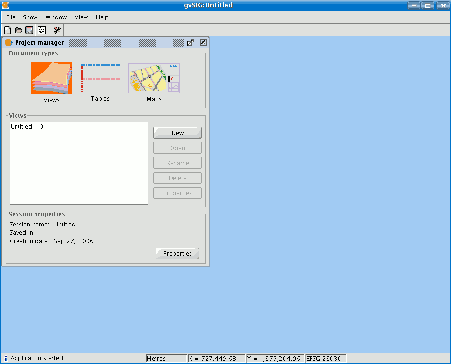
Main window
Title bar: Located at the top of the gvSIG window. It contains the programme name, i.e. “gvSIG” in this case.
Buttons to maximize or minimize the programme’s active window or to completely close it.
Main window: Work area in which the different “Project Manager” windows and the different gvSIG documents are located.
Menu bar: Some of the gvSIG functions are grouped into menus and sub-menus in the menu bar.
Toolbar: The toolbar contains the icons for the standard commands and is the easiest way to access them. By clicking and dragging the toolbars we can move them to different positions.
It is not necessary to memorize the meaning of every single icon. When you place the mouse pointer over them a message with a description of their function immediately appears.
Status bar: The status bar provides information about coordinates, distances, etc.


